
DA_Team 3

Conclusion
1. Expected Findings (Hypothesized Outcomes)
1. Comparison of Data Assimilation and Model Performance
ERA5 utilizes a hybrid incremental 4D-Var ensemble system with a high horizontal resolution of 31 km, providing precise hourly data and valuable uncertainty estimates through its 10-member ensemble. In contrast, JRA-55 applies a consistent 4D-Var system covering a long period since 1958, making it highly suitable for multidecadal climate variability studies, and it features a specialized Tropical Wind Retrieval (TWR) assimilation technique to enhance tropical cyclone representation. While ERA5 benefits from a decade of advancements in model physics and data assimilation, it exhibits a larger cold bias in the lower stratosphere compared to its predecessor, and JRA-55 is limited by its relatively lower horizontal resolution (~55 km), which can restrict the detailed depiction of fine-scale meteorological structures.
2. Tropical Cyclone Prediction and Representation
Regarding tropical cyclone prediction performance, JRA-55 demonstrates superior track accuracy by assimilating TWR data near storm centers, resulting in the smallest mean separation distances among reanalysis datasets and making it highly effective for precise trajectory tracking of storms like Typhoon Hinnamnor. Meanwhile, ERA5’s 31 km resolution allows it to simulate lower and more accurate central pressures, nearing the performance of operational high-resolution analyses for intense cases like super typhoons, while its ensemble system provides critical risk assessment information based on track variability. Ultimately, JRA-55 is advantageous for precise track analysis due to its specialized data constraints, whereas ERA5 is more suitable for analyzing record-breaking intensity, detailed internal structures, and the reliability of specific forecasts.
2. Empirical Validation:
Expected Findings vs. Observed Reality
While the technical specifications of ERA5 and JRA-55 suggest certain theoretical strengths, this study aims to verify how these translate into actual performance. The table below contrasts our expected findings, derived from the models' resolutions and assimilation systems, with the observed reality recorded during the analysis of Typhoon Hinnamnor.

3. Detailed Analysis (Items 1–6)
1. Analysis Results: Landfall
Lower level Structure (850 / 925 hPa)
ERA5 and JRA-55 exhibited distinct structural differences in the low-level wind fields at the time of landfall:
-
ERA5
-
A narrow and asymmetrically concentrated wind band exceeding 40 m/s was formed on the right side of the typhoon center (the dangerous semicircle, specifically the coastal areas of Gyeongnam and Busan).
-
The spatial concentration of the strong wind zone remained high across both the 850 hPa and 925 hPa levels.
-
-
JRA-55
-
At the same altitudes, the strong wind zone appeared relatively circular and broadly dispersed, resulting in a weaker representation of the asymmetric internal structure of the typhoon.
-
These results suggest that discrepancies in data assimilation schemes directly impact the assessment of dangerous semicircles for typhoons affecting the Korean Peninsula. Furthermore, it indicates that ERA5 provides a more precise depiction of localized gust hazard zones compared to JRA-55.
Storm-Centered Vertical Cross-Sections
-
ERA5
-
Exhibits a distinct typhoon eye structure with a sharp wind speed gradient transitioning from the eye boundary to the maximum wind zone. Strong winds are asymmetrically concentrated in the lower layers of the right side of the center (the dangerous semicircle).
-
-
JRA-55
-
The eye area appears relatively wide with blurred boundaries, and the wind speed gradient is noticeably smoother. The demarcation between weak and strong winds near the center is simulated unclearly.
-
Comparative Analysis of Wind Field and Phase Error
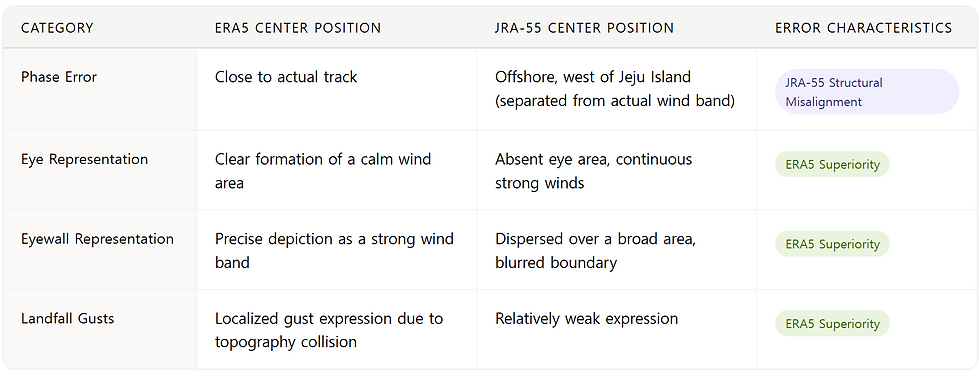
Comparing ERA5 and JRA-55 revealed notable differences in how well each dataset captures the structural detail and intensity of Typhoon Hinnamnor.
-
Structural Precision: ERA5, benefiting from its finer resolution, captured the typhoon's eye and eyewall with considerably more clarity. JRA-55, by contrast, produced a more diffuse depiction in which the boundaries between these features were difficult to distinguish.
-
Phase and Intensity Accuracy: ERA5 tracked closely with the observed storm path and wind band locations. JRA-55 showed a tendency to misplace the storm center and consistently underrepresented localized gust intensities during the landfall period.
-
Implication: Taken together, these results point to the practical advantages of higher-resolution reanalysis data when assessing the dangerous semicircle of landfalling typhoons or analyzing localized wind hazards along the Korean Peninsula.
2. Analysis Results: Peak Intensity
ERA5
-
ERA5: Captures the typhoon’s eye and eyewall structure with high precision, resolving an intense, asymmetric wind band exceeding 40 m/s concentrated in the dangerous semicircle (right side)
JRA-55
-
Represents the wind field as a broader, more diffuse circulation, with the inner-core wind signal appearing relatively weak and less defined.
Implication
-
Discrepancies in model resolution lead to critical differences in interpreting hazardous weather impacts—specifically wind radius and intensity—during the typhoon's landfall on the Korean Peninsula.
3. Analysis Results: Dissipation Stage of Hinnamnor
Structural Transformation (Lower-level)
Both ERA5 and JRA-55 effectively captured the extratropical transition (ET) signals.
-
Common Trends: The central isobaric structure collapsed into a southwestward-opening trough. The maximum wind band detached from the pressure center, reorganizing into an eastern/southeastern tail-like frontal structure.
-
Interpretation: Both models consistently simulated the transition from a warm-core tropical system to a baroclinic frontal system.
Vertical Asymmetry & Dynamic Centers
While upper-level patterns (coupling with westerly jets at 200–400 hPa) were similar, distinct discrepancies appeared in the lower levels.
-
ERA5: Reproduced a wide, well-defined calm wind zone at the center, reflecting a rapid dissipation of kinetic energy.
-
JRA-55: Showed a spatial discrepancy between the barometric center and the dynamical wind center (biased westward), indicating a relatively slower adjustment to the storm's structural decay.
Conclusion & Implications (Specific Findings)
-
Structural Tilt: The westward bias of the 850 hPa center relative to the surface track highlights the tilted vertical axis caused by the influx of cold continental air and mid-latitude troughs.
-
Model Sensitivity: The dark blue band in the difference field confirms that JRA-55 tends to overestimate wind speeds in the decaying core.
-
Final Takeaway: While both models capture the overall transition, ERA5 displays higher sensitivity in representing the rapid weakening and energy dissipation of the storm’s core after landfall.
4. Analysis Results:
Wind Speed and Vector Differences by Level: ERA5 vs. JRA-55

Table: Summary of Differential Characteristics by Level
Comprehensive Interpretation Across Levels
A synthesis of the analysis across all pressure levels reveals the following systematic trends:
-
Upper Levels (200–300 hPa): Spatial distributions of positive and negative deviations are mixed. Discrepancies in Atmospheric Motion Vector (AMV) assimilation methods are most sensitively reflected at the jet stream core level, resulting in the highest RMSD values (5.4–5.7 m/s) across all altitudes.
-
Middle Levels (500–700 hPa): Positive ERA5 deviations are concentrated within the typhoon’s stationary phase and internal warm core structure. This indicates that ERA5 provides a more robust analysis of the storm’s internal dynamics during its quasi-stationary period.
-
Lower Levels (850–925 hPa): A systematic bias is observed where ERA5 analyzes the primary circulation stronger than JRA-55. These results likely reflect differences in boundary layer physical parameterizations near the 920 hPa level.
These level-specific difference patterns are interpreted as the combined result of the following three factors:
-
Model Resolution Discrepancy: The contrast between ERA5’s high-resolution grid (31 km) and JRA-55’s coarser grid (55 km).
-
Data Assimilation Configuration: Divergent approaches in AMV (Atmospheric Motion Vector) assimilation schemes and the specification of background error covariance.
-
Physical Parameterizations: Fundamental differences in the treatment of planetary boundary layer (PBL) processes and physical physics schemes.
5. Analysis Results: Track and Intensity Discrepancies: RSMC vs. JTWC
Track Accuracy
-
General Performance: Average track error is only 13.33 km, showing high consistency between agencies during the typhoon's active phase.
-
Outlier Case: Error surged to 86.7 km during the dissipation stage (Sept 6, 12:00 UTC), reflecting different definitions of the typhoon center during extratropical transition.
Directional Bias
-
Distribution: JTWC’s position errors are evenly distributed around the RSMC reference.
-
Conclusion: No statistically significant structural or directional bias was found.
Statistical Distribution & Correlation
-
Intensity-Track Correlation: A positive (+) correlation exists. Center localization is highly accurate at peak intensity but becomes uncertain during the genesis and weakening stages.
-
Track Error (Skewed): Mean (13.3 km) > Median (11.1 km), indicating that the average is influenced by a few extreme cases.
-
Intensity Error (Normal): Shows a bell-shaped distribution with a minimal bias of +0.84 hPa, confirming no systematic bias toward either agency.
6. Final Conclusion
6-1. Comparison of Data Assimilation Performance (ERA5 vs. JRA-55)
Through the analysis of Typhoon Hinnamnor, the data assimilation performances of ERA5 and JRA-55 are categorized as follows:
Table: Comparison of Data Assimilation Performance

6-2. Summary of Key Findings
-
Structural Precision: ERA5 outperforms JRA-55 in resolving the typhoon eye, eyewall, and concentrated wind bands within the dangerous semicircle, providing superior accuracy for localized risk assessments during landfall.
-
Phase Errors: JRA-55 exhibits significant spatial misalignment (phase error) between the storm center and the actual wind band, revealing limitations in representing internal structures during the landfall stage.
-
Dissipation Stage: During the extratropical transition, both models successfully reproduce similar upper-level asymmetric structures; however, subtle discrepancies persist in the positioning of the lower-level calm center.
-
RMSD Analysis: RMSD and bias record maximum values at the upper levels (200–300 hPa), showing that AMV satellite assimilation impacts are concentrated aloft. On the other hand, spatial pattern mismatches (lower correlation) are more prominent at the lower levels (850–925 hPa). This implies that the reanalysis discrepancies go beyond simple intensity differences, evolving into structural mismatches in the circulation patterns themselves.
-
Agency Comparison (RSMC vs. JTWC): The average track error is exceptionally low (13.33 km). However, the error surges to 86.7 km during the dissipation stage, highlighting persistent uncertainties during the decaying phase.
-
Intensity Bias: With a mean intensity bias of only +0.84 hPa, there is no substantial systematic bias in intensity analysis between the two agencies.
-
Systematic Wind Speed Bias: ERA5 exhibits a systematic positive bias compared to JRA-55, analyzing stronger wind speeds across all vertical pressure levels. This is interpreted as a combined effect of ERA5's higher horizontal resolution (31 km vs. 55 km) and its more advanced AMV assimilation scheme.
-
Temporal Variation of Reanalysis Differences: During the typhoon's peak intensity phase, the RMSD between the two reanalyses temporarily decreases, whereas a pattern of sharp increases is observed during the stationary and recurvature (turning) phases. This implies that the intense dynamic forcing of a strong typhoon temporarily suppresses discrepancies between the two assimilation systems; however, differences in AMV assimilation schemes manifest more prominently when the storm weakens or interacts with complex environmental conditions.
6-3. Limitations and Future Research
-
Observational Validation: The systematic strong bias of ERA5’s lower-level primary circulation needs to be validated through direct comparison with observation data, such as dropsondes and scatterometers.
-
Causal Analysis of AMV: Further numerical simulation is required to analyze how discrepancies in upper-level AMV assimilation impact typhoon steering flows and track predictions.
-
Reducing Dissipation Uncertainty: Research into advanced assimilation methodologies using high-latitude dropsondes and satellite data is necessary to mitigate uncertainties during the dissipation stage.
-
Generalization: Since these findings are based on a single case study of Typhoon Hinnamnor, further validation across multiple typhoon cases is required for generalization.